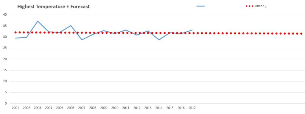
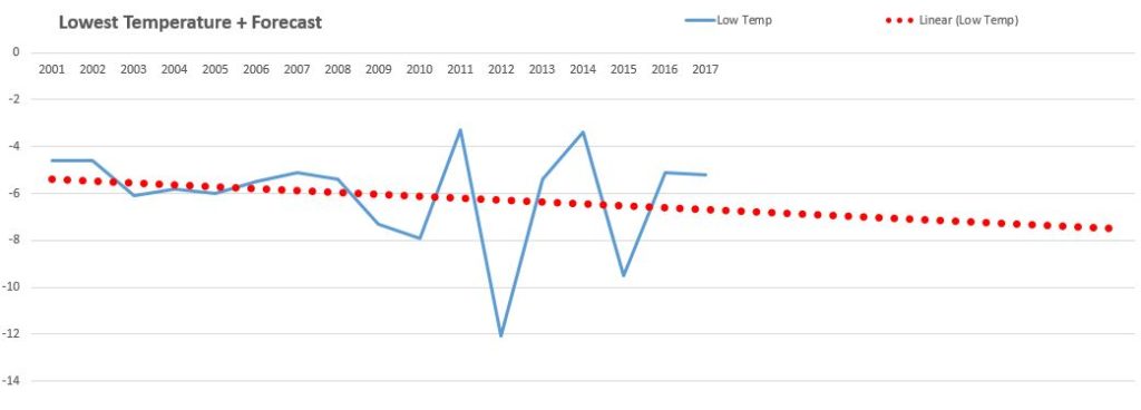
As gardeners we are much more aware of the weather and climate than most people because we are generally living day to day through the health and yields of our plants (be they flowers, fruit or vegetables). During most weeks I have an eye on the BBC Weather for the Week Ahead (iPlayer) with its frost, heat or rainfall predictions, so that I can take preemptive measures in the greenhouse or at the allotment.
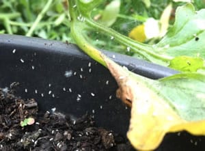
White Fly Decimating My Tomato Plants
Looking back at 2017 we had an early spring which caused the tulips to come up early (I got badly sunburned on a beach around April 9th). This was followed by quite a cloudy spell of below average temperatures in July and August which affected my pumpkins (they didn’t fruit as much which was not great for my giant pumpkins which tend to fruit later than the rest – they actually failed). The sunflowers went to sleep and the courgettes and sweetcorn with them (honestly it was a bit of a relief with the courgettes!). It was also quite wet, which increased cases of tomato blight through humidity, encouraged white fly in my greenhouse and mildew on my Dahlias. Overall summer 2017 was not good for Surrey allotment growers, spring was better.
2018 is not looking like it’s going to be an early spring. The daffodils were not up in December or January for the first time in a while, then in late February / early March we have been hit with the ‘Beast from the East’ as cold polar escapes from the North pole and comes down into Europe. It’s almost as if the bulbs knew somehow that they should hold off for a while. I’m glad I have all my flower beds well mulched! We have a caravan holiday booked for Cornwall in April – a reliably warm month these past ten years but looking increasingly like it will bring back childhood memories of a frozen Easter holiday in Great Yarmouth…
From a gardener’s perspective I thought it would be interesting to again examine the weather and temperature trends locally this century. I have updated my graphs (below) to factor in all of 2017, looking again at data from a weather station in West Sussex (yes I’m in Dorking, Surrey but Crawley isn’t far). My allotment is semi-rural so during the cold seasons I need to know if the temperatures are going to drop more significantly than in a town. In towns and cities, buildings and roads retain more heat at night and concreted roads reduce evaporation which would otherwise cool temperatures more quickly (hence it’s colder in rural locations).
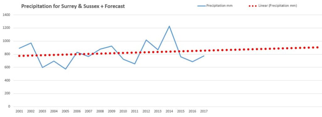
Looking at average weather station data from Crawley Down (on the outskirts of Crawley in West Sussex) I extracted their annual records manually and generated the resulting trend graphs myself. The outcomes displayed at the bottom of this article show that since 2000:
- Precipitation is increasing i.e. on average it’s getting wetter each year. 2017 was 13% wetter than 2016 (773.4mm vs. 683.4mm) but still well down on 2014 (1226.6mm).
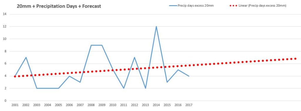
- Heavy precipitation days (days in excess of 20mm) have increased in frequency since 2000.
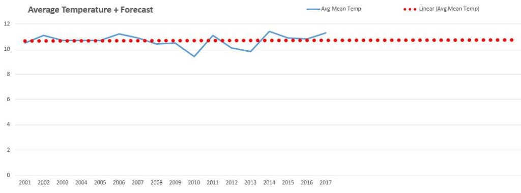
- The average temperature will increase by 0.1C between the years 2000 and 2027.
- The highest average temperature is falling (a little) – so less heat scorch risk.
- The lowest average temperature is dropping (a lot) – so a heavier frost risk.
In 2007 An IPCC study predicted that
For the next two decades, a warming of about 0.2°C per decade is projected for a range of SRES emission scenarios. Even if the concentrations of all greenhouse gases and aerosols had been kept constant at year 2000 levels, a further warming of about 0.1°C per decade would be expected.
Averaging out these local weather trends, the average temperature change in Surrey looks more like 0.033C per decade – but warming nonetheless. It is interesting that before 2017 the average temperature was cooling marginally since 2000 but at 11.3C 2017 caused a swing the other way. It’s going to be getting wetter over the next decade in Surrey and West Sussex with increased heavy rainfall events and unexpectedly hard overnight frosts. That’s good news for golf course managers and water companies but bad news for those of us growing crops like tomatoes, chillies or pumpkins. It’s probably not great news for local arable farmers either.
Preparing the allotment for wetter and more extreme weather:
There are some steps that can be taken to make an allotment or vegetable garden more suited to wetter and more extreme climate:
- Use raised beds to grow crops, raised beds will drain more quickly and not hold water which when standing can rot root crops or alliums / onions and/or increase diseases like club root in cauliflowers.
- Fertilise beds more regularly because the excess precipitation will wash away the nutrients plants need to grow.
- Be prepared to cover fragile crops with grow tunnels at short notice to protect them from unexpected heavy rain or hail incidents.
- Learn to love cold weather crops like Brassicas (cabbages, Brussels sprouts, broccoli), potatoes, swedes and carrots.
- To reduce ‘rust’ grow leeks in small spread out groups across your plot not in rows (this also helps stop the spread of Allium Leaf Miner / ALM).
- Install a polytunnel or two to provide additional heat for the warm climate plants like tomatoes. Polytunnels also provide additional protection from blight.
- Obtain one or two water butts to gather all this excess water for use in your polytunnel(s).
- Expect higher slug populations and encourage toads and frogs into your plot top eat them (perhaps add a pond), this is a much better solution than increasing use of wildlife harming slug pellets.
- Dig drainage ditches along the sides of your plot if flooding is becoming a problem, most likely on heavy clay allotments like mine…
- Plant more fruit trees to help retain top soil and prevent it from washing away into rivers and streams.
Here are the graphs showing the data recorded by the Crawley Down Weather Station. I have added in trend lines with projections for the next decade to 2027 should rates of change continue as they have since 2000

